Field & Sales Ops Product Design - Modernizing Termite Inspections: Geospatial Diagramming Tool
I turned a manual inspection process into a modern, geospatial diagramming tool that streamlined workflows and won strong buy-in from sales and operations.
- Client
- Aptive Sales & Field Ops
- Year
- Service
- Field & Sales Ops Product Design
Overview
Legacy termite inspections have historically relied on hand-drawn diagrams, creating inefficiencies in the field and friction in sales workflows. I redesigned this process by creating a browser-based geospatial diagramming tool that modernized inspections, improved clarity, and streamlined communication between technicians and sales teams.
Context and Problem Definition
To understand the inspection workflow firsthand, I completed the same certification exams as our installers and shadowed sales reps and technicians across many of our active termite areas in the country.
While I observed that treatment technology had evolved, the inspection and documentation process remained paper-based. State regulations require a detailed property diagram before a termite service can be sold, and reps were manually measuring and sketching each home — adding 10–15 minutes per inspection.
This created three problems:
• Slower sales cycles
• Inconsistent documentation quality
• A less professional closing experience
Sales reps and technicians openly expressed frustration with hand-drawn diagrams and wanted a more polished, customer-facing solution.
Adding 10–15 minutes per inspection across dozens of inspections per week (per area) represented a meaningful operational inefficiency across the entire sales org.
How might we modernize inspection documentation to reduce friction and elevate the sales experience?
Strategic Approach
Solutions I Explored:
• A native mobile AR tool
• Third-party satellite view measurement vendor
• Browser-based satellite diagramming system
In the end, I chose a progressive web app (PWA) to:
• Avoid native app framentation
• Eliminate vendor dependency
• Ensure access for both sales and field technicians
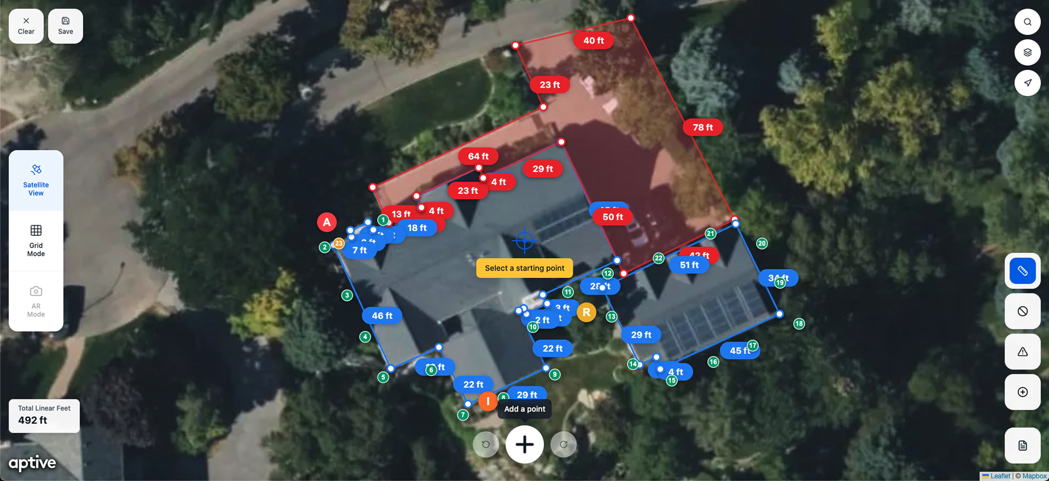
The Solution
A browser-based satellite measurement tool that enables:
• Point-to-point linear footage calculation
• Tagging of active, inactive, and high-risk zones
• Undo/redo state management
• PDF export for compliance documentation
Measure Mode
After testing the measurements in person with a measure wheel and a laser, I was impressed with how accurate Leaflet's scale was. The measurements were acurate within inches - well within the tolerance we need for termite inspection diagrams.
Reporting Issues Mode
Reps can easily pin point and report active/inactive termite and at-risk areas, along with detailed notes and photos. This really strengthens the ability to close sales at the completion of the inspection when they're reviewing it with the customer.
Bait Stations Mode
Reps can easily pin point and document where each bait station will be placed around the home.

Fully Adjustable
Any measurement, reported issue, or bait station can be moved, edited, or deleted. This is especially helpful for meeting customer preferences and gives future technicians the ability to adjust as needed.
Validation
Tested with 12+ stakeholders across:
• Termite sales reps
• Field operations leadership and technicians
• Sales strategy and training leadership
Results:
• Immediate usability with minimal instruction
• Strong enthusiasm from both sales and field teams
• Training leadership expressed interest in onboarding integration
• Clear signals of adoption readiness
Outcome
The prototype was positively received across departments. The project demonstrated the feasibility of a browser-based compliance tool, strong internal demand for modernizing the legacy inspection process, and effective AI-assited rapid protoyping.
The Team
• Product Manager
• Product Designer (me)
• QA Engineer
• 2-3 Frontend Engineers
• 1-2 Backend Engineers
My Role
Due to limited engineering and product management bandwidth, I led the design, research, and execution of this project. I organized and conducted research, engaged stakeholders, implemented feedback, tested and validated assumptions, and iteratively refined the prototype. I was the sole designer and developed the initial prototype used for early testing.
Tech Stack and Tooling
- React + TypeScript
- Leaflet + Mapbox
- ShadCn / TailwindCSS
- Client-side PDF export
- Deployed on Vercel
- VS Code
- Github Copilot
- Claude Models